

Location
Nanga Parbat is the western anchor of the Himalayas and is the westernmost eight-thousander. It lies just south of the Indus River in the Astore District of the Gilgit-Baltistan in Pakistan administered Kashmir. Not far to the north is the western end of the Karakoram range
 Rupal Face
Notable features
Nanga Parbat has tremendous vertical relief over local terrain in all directions. To the south, Nanga Parbat boasts what is often referred to as the highest mountain face in the world: the Rupal Face rises 4,600 m (15,000 feet) above its base. To the north, the complex, somewhat more gently sloped Rakhiot Flank rises 7,000 m (22,966 feet) from the Indus River valley to the summit in just 27 km, one of the 10 greatest elevation gains in so short a distance on Earth.
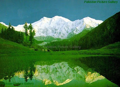
Nanga Parbat from Fairy Meadows At 4,100 meters, near the Rakhiot Base Camp
Layout of the mountain
The core of Nanga Parbat is a long ridge trending southwest-northeast. The ridge is an enormous bulk of ice and rock. It has three faces, Diamir face, Rakhiot and Rupal. The southwestern portion of this main ridge is known as the Mazeno Wall, and has a number of subsidiary peaks. In the other direction, the main ridge arcs northeast at Rakhiot Peak (7,070 meters). The south/southeast side of the mountain is dominated by the massive Rupal Face, noted above. The north/northwest side of the mountain, leading to the Indus, is more complex. It is split into the Diamir (west) face and the Rakhiot (north) face by a long ridge. There are a number of subsidiary summits, including North Peak (7,816 m) some 3 km north of the main summit. Near the base of the Rupal Face is a beautiful glacial lake called Latbo, above a seasonal shepherds' village of the same name.
Approaching Nanga Parbat Base Camp View from Latbo village. Notice a tiny yellow tent at the bottom right.
 First Ascent
Nanga Parbat was first climbed on July 3, 1953 by Austrian climber Hermann Buhl, a member of a German-Austrian team. The expedition was organized by the half-brother of Willy Merkl, Karl Herrligkoffer from Munich, while the expedition leader was Peter Aschenbrenner from Innsbruck, who had participated in the 1932 and 1934 attempts. By the time of this expedition, 31 people had already died on the mountain. The final push for the summit was dramatic: Buhl continued alone, after his companions had turned back, and arrived at 7 p.m.; the climbing being harder and more time consuming than he had anticipated. His descent was slowed when he lost a crampon, and caught by darkness he was forced to bivouac standing upright on a narrow ledge, holding a small handhold with one hand. Exhausted, he dozed occasionally, but managed to maintain his balance. He was also very fortunate to have a calm night, so he was not subjected to wind chill. He finally reached his high camp at 7 p.m. the next day, 40 hours after setting out.The ascent was made without oxygen, and Buhl is the only man to have made the first ascent of an 8000m peak alone.


1 comment:
The article on Nanga Parbat is very good.
Mats Lundkvist
http://budurl/3vgb
Post a Comment